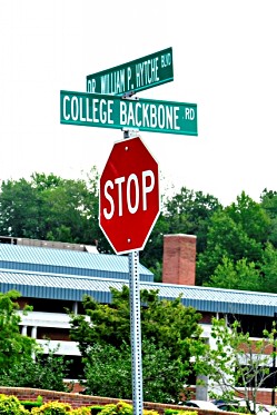
dedicated in 2008
The 745-acre University of Maryland Eastern Shore campus at its 125th anniversary had grown an astronomical 4,556 percent since its founding in September 1886.
That kind of expansion during the first 125 years resulted in transformations and reconfigurations that often left older alumni in awe.
What remains constant is the legacy of people who shaped the institution’s foundation. One way they are remembered is by a roadway named in their honor. William P. Hytche, who died in 2007, is credited as the chief advocate for recognizing their contributions in that way.
With assistance from the university’s public safety department, which utilizes emergency preparedness maps, following is a list of streets, roads and drives that reflect a partial snapshot of the institution’s story:
College Backbone(1) Road (County Rt. 303) — was the main access to campus and at one time meandered past the front of the administration building built in the late 1930s.
Marksman Drive — the entrance to Eldon Hall Farm, university-owned property off College Backbone Road on the east side of campus. The farm was the homestead of Dr. Eldon G. Marksman, a beloved campus physician.
Vaughn Road — named for Dr. Moses W. Vaughn, a chemistry professor and chairman of the department of agriculture when the institution was known in the mid-20th century as Maryland State College. It flanks the Food Sciences and Technology Center on the west.
Marion Drive — named for Dr. Claud C. Marion, a colleague of Vaughn and an agriculture education and teacher-training professor. It flanks the Food Sciences and Technology Center on the east.
Strickland Drive — named for John V. Strickland, a poultry husbandry / economics professor and another Vaughn contemporary. It is adjacent to the physical plant that opened in 2004 on the east side of campus.
McCain Drive — named for legendary football coach, Vernon E. “Skip” McCain, credited with making Hawk gridiron teams a black college football dynasty in the post-World War II era. A remnant of the original College Backbone Road, it stretches 350 yards from the Student Clusters housing complex to Harford Hall in the center of campus.
Art Shell Plaza — named for the university’s most celebrated professional athlete. It provides access to on-campus housing known as the Student Apartments off McCain Drive.
Academic Oval — a reconfigured remnant of a section of College Backbone Road that was rerouted into a perimeter road.
Dr. William P. Hytche Boulevard — (Maryland Rt. 918) dedicated in 2008 to honor the top administrator at the university from 1975 to 1997 considered the architect of the modern-era campus. The renamed two-block stretch of Broad Street connects Somerset Avenue, Princess Anne’s main thoroughfare, to the original entrance of campus.
UMES Boulevard — (Maryland Rt. 822) – completed in 2001, it replaced Hickory Road to provide access to the university from U.S. Rt. 13, the Delmarva Peninsula’s main north-south highway
University Boulevard South — the road on the south side of campus winds from the Hytche Boulevard-College Backbone Road intersection past Kiah Hall, the Henson Center, Hazel Hall, Murphy Hall Annex, George Washington Carver Hall and connects with Strickland Drive.
Dean Harris Court — named for Francis H. Harris, long-time dean of men in the early days of Maryland State. It is the entrance drive to modest brick bungalows originally built as faculty housing [off McCain Drive].
Hawks’ Lane — provides vehicular access to the golf driving range off College Backbone Road. The name previously defined a now-defunct drive where the physical plant has stood since 2004.
Student Services Center Lane — east entrance to the building (from College Backbone Road) that is the focal point of student life activities.
Prosperity Circle — west entrance to the Student Services Center (from College Backbone Road) that leads to traffic turnaround area.
Tom Nichols(2) Road — provides access from West Post Office Road (Maryland Rt. 388) to UMES’ 17-acre solar power collection facility that opened in March 2011.
John Wilson Lane — a private drive on the east side of campus that serves the Lower Shore offices of the Maryland Fire and Rescue Institute. John Augustus Wilson was the quintessential 1960s student activist at Maryland State, which he attended from 1963 to 1965. A decade later, he campaigned to institute home rule in Washington, D.C. and served as an elected city councilman from 1975 until his death in 1993.
Martin Court — named for Louis H. Martin, who was Maryland’s first black agriculture extension agent at Princess Anne Academy (as the university was known in that era). Now decommissioned, the most recent Somerset County map prepared by the Maryland State Highway Administration shows it served as an entrance drive from College Backbone Road to greenhouses and poultry research buildings adjacent to the university’s physical plant.
(1)– The unusual name likely refers to what was a farm-to-market trail along the crest (or “backbone) of a ridge stretching from the UMES campus north to Backbone Hill in the Eden area.
(2) – Thomas David Nicholls was a member of the U.S. House of Representatives from Pennsylvania’s 10th Congressional district from March 1907 to March 1911. When he left office, he moved to the Princess Anne area, where he operated a poultry farm until his death Jan. 19, 1931. He and his wife, Sarah, are interred in the Antioch United Methodist Church cemetery in Princess Anne. It was not uncommon for his last name to be misspelled with one “L,” according to an archive of organized labor managed by the University System of Maryland’s College Park campus.

